![]()
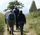
Walking routes in Charlbury
Explore the Oxfordshire Cotswolds
Located beneath the ancient forest of Wychwood, in the Cotswolds Area of Outstanding Natural Beauty, Charlbury is the ideal place for a country walk.
With hourly express trains from London Paddington, Reading and Oxford, there's no need to bring the car. You'll find a warm welcome in the town's shops and four pubs, and accommodation is plentiful.
Our recommended walks include full route descriptions and clear Ordnance Survey mapping - just choose from the menu on the left. We'll be adding more in the weeks to come. If you have a suggestion for a walk, or would like to comment on any of these walks, do contact us.
Maps
If you are relying on maps to plot your own walks, be re-assured: the rights of way shown on the Ordnance Survey maps are mostly very clearly marked on the ground.
The only problem is that Charlbury is on the edge of two Explorer maps (the best for walking, as they show a great deal more detail, including field boundaries). The town itself is on map 180 ('Oxford') and includes the circular walk via Finstock through Wychwood Forest; the Oxfordshire Way to Stonesfield and Woodstock (the path is one of several extensive rights of way in Blenheim Park offering some very attractive walks for free); and many attractive paths around Finstock (The Plough is highly recommended), Ramsden (another excellent pub, The Royal Oak), Wilcote and North Leigh (The Woodman).
However, map 191 ('Banbury, Bicester and Chipping Norton') begins on the northern edge of the town and guides you to the very attractive wooded Ditchley Park where there are several walks within the estate, or with more time and energy you can walk through the park and enjoy an extremely pleasant circular walk taking in Kiddington Park, Cleveley and Church Enstone (where there is an excellent pub, The Crown). If you take the circular route, you return from The Crown via Spelsbury and Coldron Mill, the paths being clearly marked on the map.
Also on map 191 are the walks along the Glyme valley from Enstone, north to Chipping Norton, and south towards Woodstock. The Glyme valley has a very special feel to it, quite different from the Evenlode valley round Charlbury.
The Oxfordshire Way follows the river Evenlode east towards Woodstock (see above), and west towards Ascott-, Shipton- and Milton-under-Wychwood, dodging between the two maps. Beyond Ascott, you will need the Outdoor Leisure Cotswolds map, which covers a vast area from Cirencester in the south to Chipping Campden in the north. When walking west from Charlbury, be sure not to miss the wall paintings in Shorthampton church.
If you are visiting briefly and will not be doing very much walking, you will probably find all you need on the Landranger map 164 ('Oxford'). The scale is not so detailed, but it shows pretty much the whole area you can reach on foot and all on one map.
Bus and train walks
You can enhance your walks in some instances by walking in one direction and catching the bus in the other, though Charlbury is not served by buses on Sundays. This makes the walk to Woodstock much more practicable for most people (take in the Roman Villa at North Leigh on the way, and follow the Roman road of Akeman Street through Blenheim Park), as there are hourly daytime buses to and from Woodstock. A walk to Chipping Norton via Chadlington, or via Enstone and up the Glyme Valley, can also be rounded off with a bus home. Similarly, walks can be planned with the train timetable, using the services to and from Kingham, Ascott and Hanborough stations. All trains on the line stop at Charlbury.
Walking guides
There are countless handbooks for walkers, but most cover large areas (such as Oxfordshire, the Thames Valley, or the whole of the Cotswolds). Only one consists entirely of walks that start from, or near to, Charlbury itself: Country Walks 1: Evenlode and Wychwood. The companion volume is Country Walks 2: The Glyme Valley. They are currently out of print but may be available from online booksellers. Both were published in Charlbury by the Wychwood Press. The guides are full of useful and interesting information about what you will see on the walks, and they include maps which really make the Landranger maps unnecessary for those occasions at least.